- CA ON00239 F1411-S23-f4-2
- Pièce
- [Copied ca. 1990] (originally created [191-])
Fait partie de Kingston Picture collection
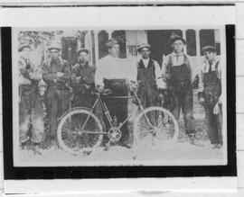
Group photograph of unidentified Kingston Conductorettes.
2046 résultats directement liés Exclure les termes spécifiques
Fait partie de Kingston Picture collection
Group photograph of unidentified Kingston Conductorettes.
Fait partie de Kingston Picture collection
Item is a photograph of telephone operators sitting in front of the switchboard.
Fait partie de Kingston Picture collection
View of the Line Crew of Kingstons telephone service.
Brosius Map of Kingston, 1875.
Fait partie de Kingston Picture collection
A 'Birds Eye View' of Kingston. Detailed map of Kingston by H. Brosius with insets of the 'Insane Asylum', the 'Penitentiary' and 'Kingston Harbour from Gunn's Wharf.' This is a complete copy of the map taken from the original lithograph.
Brosius, H.
Brosius Map of Kingston, 1875.
Fait partie de Kingston Picture collection
The Pickardsville section only of the Brosius map of Kingston.
Brosius, H.
Brosius Map of Kingston, 1875.
Fait partie de Kingston Picture collection
The Charlesville section only of the Brosius map of Kingston.
Brosius, H.
Brosius Map of Kingston, 1875.
Fait partie de Kingston Picture collection
Part of the right section only of the Brosius Map of Kingston.
Brosius, H.
Fait partie de Kingston Picture collection
1973 reproduction of the 1875 Brosius map of Kingston.
Brosius, H.
Fait partie de Kingston Picture collection
Site record drawing of the Canadian Forces Base at Kingston. Most buildings are identified.
Canada. Department of National Defence
Fait partie de Kingston Picture collection
Composite plan of Fort Frontenac, 1869 by Charles Walkham. Walkham shows the main gate to the Tete de Pont barracks projecting out into Ontario Street as it did for most of the nineteenth century and the Grand Trunk Railway line crossing the inner harbour on a causeway and passing over the former quarters of the French commandants of Fort Frontenac.