- CA ON00239 F1411-S24-f8-1
- Pièce
- 1632
Fait partie de Kingston Picture collection
Detailed map of "Carte de la nouvelle France..." by Samuel de Champlain.
132 résultats avec objets numériques Afficher les résultats avec des objets numériques
Fait partie de Kingston Picture collection
Detailed map of "Carte de la nouvelle France..." by Samuel de Champlain.
Fait partie de Kingston Picture collection
Plans of Point Frederick and Point Henry by George Williams.
Old Fort Henry - Architectural Drawing
Fait partie de Kingston Picture collection
Architectural drawing inscribed 'Plan of the Fort/at/Point Henry/in its present state, May 1814'. Copied by Geo.Williams/Rt. M.J.Surveyor, 24 June 1814.
Fait partie de Kingston Picture collection
View of the S.Anglin & Co.'s Lumber Mill. Lumber and coal merchants.
Fait partie de Kingston Picture collection
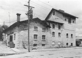
Item is a photograph of a side view of the Bajus Brewery building on Wellington Street.
Lilley, George E.O.
Fait partie de Kingston Picture collection
Angled view of the plant of 'Cereals Limited'.
Fait partie de Kingston Picture collection
Unidentified sailing ship and skiff at dock. Elevator in background.
Fait partie de Kingston Picture collection
Three views looking west on Concession Street at the corner of Division Street.
G. Lay
Fait partie de Kingston Picture collection
Three views looking north at the corner of Division and Colborne Streets.
Fait partie de Kingston Picture collection
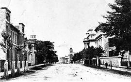
Item is a photograph of King Street. It is a view looking north along King Street from north of Earl Street. To the right is the edge of former town property of J.S. Cartwright; next is the Bank of Montreal which later became the Frontenac Club; then the Commercial Bank (which is now Empire Life Building). In the distance is the clock tower of the King Street wing of City Hall which burned in 1865. At the far left of the photograph is Saint Georges' steeple and 224-226 King Street E.