- CA ON00239 F1411-S24-f3-2
- Pièce
- [ca. 1740]
Fait partie de Kingston Picture collection
Item is a photograph of the "Plan du Fort Frontenac ou Cataracouy' ca.1740. The original was pen & ink with watercolour. Surveyor unknown.
132 résultats avec objets numériques Afficher les résultats avec des objets numériques
Fait partie de Kingston Picture collection
Item is a photograph of the "Plan du Fort Frontenac ou Cataracouy' ca.1740. The original was pen & ink with watercolour. Surveyor unknown.
Fait partie de Kingston Picture collection
Plan of old Frot Frontenac and town plot of Kingston, 1784. Surveyed by John Frederick Holland. Original is coloured manuscript plan with sacle of 1' to 1 chain. Inset is elevations and ground plans of new British barracks.
Fait partie de Kingston Picture collection
'Plan of the City and Liberties of Kingston, 1850.' by Thomas Fraser Gibbs. Copied from an original lithograph. The map shows that intensive building and settlement had not proceeded much beyond Barrie and Division Streets to the West, and North St. to the North. The liberties were areas which were under municipal control, but which had no voting privileges and paid lower taxes.
Fait partie de Kingston Picture collection
Map of the City of Kingston & Suburbs. Map shows Concession 'Road' as the City Limits.
Fait partie de Kingston Picture collection
Map of Odessa ca. 1850(?)
Fait partie de Kingston Picture collection
Item is a photograph of a plan of Point Frederick & Point Henry. Assignment of lots.
Fait partie de Kingston Picture collection
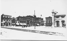
Item is a photograph of a view of Kingston's Market Square looking northeast across Brock Street.
Fait partie de Kingston Picture collection
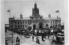
Item is a photograph of a view of the Market Square filled with wagons and horses, and of City Hall flying the Union Jack. The original image dates around 1890.
Fait partie de Kingston Picture collection
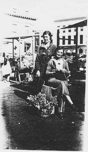
Item is a photograph of Hilda Fearn and unidentified woman at their stall on Market Square.
Fait partie de Kingston Picture collection
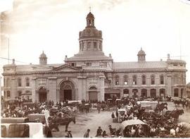
Item is a photograph of a view of the Market Square filled with horses and wagons and the King Street facade of City Hall.