- CA ON00239 F1411-S29-89
- Item
- [ca. 1750]
Part of Kingston Picture collection
Photo of an oil portrait on canvas by an unknown artist.
239 results with digital objects Show results with digital objects
Part of Kingston Picture collection
Photo of an oil portrait on canvas by an unknown artist.
Part of Kingston Picture collection
Map of Lake Ontario by Pierre Boucher de Labroquerie, copied by C. Pettigrew. Pen & ink tracing of original. Insets on map show Fort Ontario, Fort Choueguen, English fleet, Fort Niagara, French fleet, Fort Frontenac.
Part of Kingston Picture collection
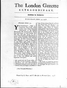
Item is a photograph of an excerpt from the "London Gazette Extraordinary" reporting an attack by Bradstreet on Fort Frontenac.
Part of Kingston Picture collection
Item is a photograph of a pen & ink with wash map by L.P. Vallerand of 'Vue de Frontenac ou Cataracoui'.
Part of Kingston Picture collection
A view of the ruins of the Fort at Cataraqui. Pen and ink and watercolour.
Part of Kingston Picture collection
A southeast view of Cataraqui on Lake Ontario. Pen, ink and watercolour.
Part of Kingston Picture collection
Photograph is inscribed "VIEW OF CATARAQUI (KINGSTON)./Showing the remains of old Fort Frontenac in 1783."
Part of Kingston Picture collection
A View of Cataraqui on the entrance of Lake Ontario in Canada taken from Capt. Brants house July 16,1784. Pen and ink and watercolour.
Part of Kingston Picture collection
Plan of old Frot Frontenac and town plot of Kingston, 1784. Surveyed by John Frederick Holland. Original is coloured manuscript plan with sacle of 1' to 1 chain. Inset is elevations and ground plans of new British barracks.
Part of Kingston Picture collection
Excerpt from Richard Cartwright's Letterbook, 1785-1786, which is among the best documentary sources for early commercial history of Kingston. Open at a letter to the Montreal firm of Todd & McGill on the 13th of February 1786.