- CA ON00239 F1411-S24-f5-9
- Einzelstück
- 1865
Teil vonKingston Picture collection
City plan of the 'City of Kingston, County of Frontenac, Canada West by John C. Innes, 1865.
132 Treffer mit digitalen Objekten Treffer mit digitalen Objekten anzeigen
Teil vonKingston Picture collection
City plan of the 'City of Kingston, County of Frontenac, Canada West by John C. Innes, 1865.
Teil vonKingston Picture collection
"Plan of Lots 98 & 107 accordng to the original survey of Town of Kingston, now City of Kingston. Scale 20 to 1". Registered plan of 1949 Land Registry Instrument.
Teil vonKingston Picture collection
Map of the City of Kingston. Scale is 660 feet to 1 inch.
Crowe, Michael
Teil vonKingston Picture collection
Teil vonKingston Picture collection
Plans for the locks at Kingston Mills, 1831 by Lieut. Col.John By.
Teil vonKingston Picture collection
Map of Lake Ontario by Pierre Boucher de Labroquerie, copied by C. Pettigrew. Pen & ink tracing of original. Insets on map show Fort Ontario, Fort Choueguen, English fleet, Fort Niagara, French fleet, Fort Frontenac.
Teil vonKingston Picture collection
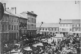
Item is a photograph of the Kingston Market Square filled with horses and wagons. View also includes Market Street and King Street.
Teil vonKingston Picture collection
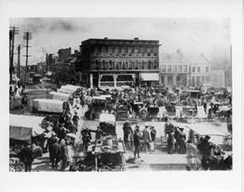
Item is a photograph of a view of Market Square filled with wagons. View includes the Crown Bank of Canada on King Street.
Teil vonKingston Picture collection
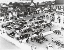
Item is a photograph of a view of Market Square filled with trucks and vendor stands, looking north across Brock Street.
Nagle, Kevin T.
Teil vonKingston Picture collection
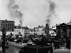
View of Market Square in winter, some vendors are selling Christmas trees. View also includes Brock Street and the back of City Hall.
Nagle, Kevin T.