- CA ON00239 F1411-S24-f4
- Unidad documental compuesta
- 1744
Parte deKingston Picture collection
File consists of images of maps of the Great Lakes.
239 resultados con objetos digitales Muestra los resultados con objetos digitales
Parte deKingston Picture collection
File consists of images of maps of the Great Lakes.
Parte deKingston Picture collection
Map of the Great Lakes by N. Bellin. Scale of 1' to about 63 miles. Inscription on map: (translation) "Map of the lakes of Canada, based on manuscripts in the marine repository of maps, plans and journals and on the journal of Father de Charlevoix. By N. Bellin, Engineer and Hydrographer of the Navy 1744."
Parte deKingston Picture collection
Photo of an oil portrait on canvas by an unknown artist.
Parte deKingston Picture collection
File consists of images of maps of Lake Ontario.
Parte deKingston Picture collection
Map of Lake Ontario by Pierre Boucher de Labroquerie, copied by C. Pettigrew. Pen & ink tracing of original. Insets on map show Fort Ontario, Fort Choueguen, English fleet, Fort Niagara, French fleet, Fort Frontenac.
Parte deKingston Picture collection
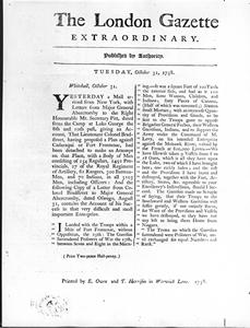
Item is a photograph of an excerpt from the "London Gazette Extraordinary" reporting an attack by Bradstreet on Fort Frontenac.
Parte deKingston Picture collection
Item is a photograph of a pen & ink with wash map by L.P. Vallerand of 'Vue de Frontenac ou Cataracoui'.
Parte deKingston Picture collection
A view of the ruins of the Fort at Cataraqui. Pen and ink and watercolour.
Parte deKingston Picture collection
A southeast view of Cataraqui on Lake Ontario. Pen, ink and watercolour.
Parte deKingston Picture collection
Photograph is inscribed "VIEW OF CATARAQUI (KINGSTON)./Showing the remains of old Fort Frontenac in 1783."